Report on the Development of China’s Net Zero-carbon City: The Shenzhen Index ranks first in total, and it has entered the stage of decoupling economic development from carbon emissions.
Recently, Nancai Chengtong and the Carbon Neutralization Research Group of 21st Century Economic Research Institute released the Report on the Development of China’s Net Zero Carbon City (2022) (hereinafter referred to as the "Report").
The Report comprehensively considers the strategic positioning, development level, carbon emission information disclosure and other factors of cities, selects 30 cities as samples, constructs an evaluation index system of net zero-carbon cities, and evaluates the net zero-carbon development level of 30 sample cities from multiple dimensions.
The 30 sample cities are Shanghai, Beijing, Shenzhen, Guangzhou, Chongqing, Suzhou, Hangzhou, Wuhan, Nanjing, Tianjin, Ningbo, Qingdao, Wuxi, Changsha, Foshan, Quanzhou, Jinan, Nantong, Xi ‘an, Fuzhou, Dongguan, Xuzhou, Tangshan, Dalian, Wenzhou, Kunming, Changchun, Shenyang, Xiamen and Yangzhou.
In the overall ranking of the net zero-carbon development level of 30 cities, Shenzhen ranks first with great advantages.
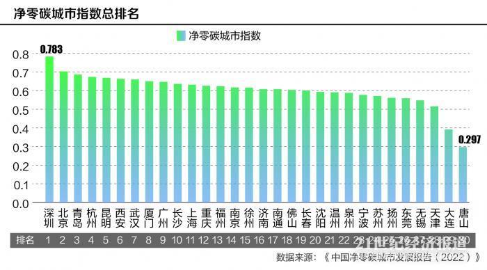
According to the Report, in the overall ranking of the net zero-carbon development level of 30 cities, Shenzhen has obvious advantages such as low-carbon emission intensity and high development quality. As the first batch of low-carbon pilot cities, Shenzhen’s low-carbon development has many bright spots, ranking first in the total carbon emissions per unit GDP, energy consumption per unit GDP, per capita energy consumption and other indicators, which are the core indicators of a net zero-carbon city, showing that Shenzhen’s energy utilization efficiency and industrial green transformation quality are high.
The great energy of "small space city"
The Report sets four secondary indicators, namely, carbon emission index, energy structure index, energy consumption index and development quality index. Among them, among the secondary indicators of "development quality index", Shenzhen ranks first among 30 cities, and other secondary indicators are basically among the best.
The quality of development involves the quality of economic development and the quality of green development. Among them, the quality of economic development mainly measures urban economic aggregate, development speed, people’s living standards, urbanization level, etc., while the quality of green development mainly measures urban air quality, green coverage rate, solid waste treatment level and urban carbon sink level.
As the third city of China’s economic aggregate, Shenzhen’s per capita GDP has exceeded 170,000 yuan in 2021, and its GDP per unit area is far ahead of other cities. At the same time, it is the only city with a urbanization rate of 100%. The quality of economic development and urbanization rate add a lot of color to its low-carbon development.
Shenzhen’s economic development is also a green development. In the quality indicators of green development, Shenzhen also has a good performance. For example, in 2020, the excellent rate of ambient air quality in the city is as high as 97%, and the green coverage rate of urban built-up areas exceeds 43%, both of which belong to a high level.
It is worth noting that the Report lists the indicators of urban carbon sinks separately, because the development of urban carbon sinks is another important path to a net zero-carbon city besides the traditional means of emission reduction. At present, its role is relatively small, and there are great differences in resource endowment, geographical location, climate conditions, area size and urbanization rate among different cities in China. As an important supplementary means, urban carbon sinks will play a greater role in the future. China promises to achieve carbon neutrality by 2060, but it is difficult to completely reduce the greenhouse gas emissions caused by human activities, and carbon absorption is needed to neutralize the emissions. Ecosystem carbon sink is the most mature carbon absorption approach with the current accounting method and implementation technology.
In order to compare the overall carbon sink capacity of cities during the Thirteenth Five-Year Plan period, the Report sums up the annual carbon sinks per unit area of cities and obtains the total carbon sink capacity per unit area of cities during the Thirteenth Five-Year Plan period. Among the 30 sample cities, Shenzhen ranks sixth in carbon sink per unit area.
This achievement is not easy to achieve. Shenzhen is a typical "three big cities and three small cities", that is, a big city with economy, industry and population, but also a small city with space, resources and environmental capacity, with an area of less than 2,000 square kilometers (excluding the Shenzhen-Shantou Special Cooperation Zone). However, Shenzhen insists on establishing an ecological city, takes the lead in putting forward the concept of basic ecological control line in the country, and includes nearly 50% of the city area in the case of extremely tight land development space.
Economic development and carbon emissions are decoupled.
The core of the development of a net zero-carbon city is to find a win-win path between economy and low carbon, and the most direct evaluation criterion is to look at the carbon emission level per unit GDP of the city, that is, the carbon emission intensity. In the index of carbon emissions per unit GDP, Shenzhen has achieved the first place.
In 2010, Shenzhen was included in the first batch of national low-carbon pilot cities. Since then, Shenzhen has increased investment in policies, funds and resources, and achieved great results.
According to the carbon emission intensity in 2020, Shenzhen has reached the advanced level in the world. In the process of continuous decline of carbon emission intensity, Shenzhen’s economic development level continues to rise. Shenzhen’s ultra-low carbon emission intensity is the result of continuous optimization of its industrial structure and energy structure, and measures are taken from the source and the end.
In 2021, Shenzhen’s GDP exceeded 3 trillion yuan. According to the three industrial structures, the proportion of the secondary industry in Shenzhen will still be 37% in 2021, and the total industrial output value will exceed 4 trillion yuan for the first time, ranking first among cities in China. Although industry still occupies a high proportion, thanks to the continuous industrial transformation, the added value of strategic emerging industries in Shenzhen has accounted for nearly 40% of GDP, and high-tech industries have been the areas where the four pillar industries have contributed the most.
In terms of optimizing energy structure, Shenzhen has completely eliminated civil loose coal and common industrial and commercial coal. There is only one coal-fired power plant in the city, and the installed capacity of clean power sources such as nuclear power and gas electricity accounts for more than 3/4 of the city’s total installed capacity.
According to the Report, in 2020, Shenzhen ranked third among the 30 cities in terms of power generation, but its carbon emission on the power generation side was very low, and the carbon emission per unit power generation was also at the lowest level in the sample cities, which was due to the optimization of power generation structure.
In addition to the optimization of industry and energy structure, Shenzhen’s performance in promoting new energy vehicles is particularly remarkable. In 2009, Shenzhen began to promote pure electric vehicles; By 2010, pure electric cruise taxis will be gradually introduced; In 2015, the pure electric logistics vehicle will be implemented; In 2017, Shenzhen realized the electrification of buses, making it the largest and most widely used city in the world for pure electric buses. In 2018, cruise taxis were fully electrified, and Shenzhen became the only city in China to realize pure electrification of cruise taxis, and it is also the city with the largest number of pure electric cruise cars in the world; In 2020, Shenzhen will realize the complete and pure electrification of the network car and sanitation vehicle. By the end of 2020, the number of new energy vehicles in Shenzhen has reached 480,000, accounting for about 14% of the total number of motor vehicles in the city-Shenzhen has been the city with the largest number of new energy vehicles registered in the world for six consecutive years, and it is also the city with the fastest and highest penetration rate of new energy vehicles in China.
The Report also shows that in recent years, the economic volume of Shenzhen has been expanding, but the carbon emission index has fluctuated and declined, and economic development and carbon emissions have shown a decoupling trend.
Energy consumption index per unit GDP is the lowest.
In the secondary index of energy consumption index, Shenzhen achieved the second place.
Energy consumption refers to the energy consumed in production and life, which mainly measures the degree of regional economic development and industrialization process. The urban energy consumption index focuses on the differences in quantity and structure of urban energy consumption and electricity consumption. Economic development is accompanied by the growth of energy consumption, which not only supports economic growth, but also brings pollution and destruction. Under the impact of COVID-19 epidemic, how to coordinate the relationship among economic growth, energy consumption and carbon emissions is the key to achieve high-quality economic development.
Among them, among the three indicators under the energy consumption index, Shenzhen has the lowest energy consumption index per unit GDP. Energy consumption per unit GDP, that is, energy intensity, is mainly used to compare the comprehensive utilization efficiency of energy in different regions, which reflects the economic benefits of regional energy utilization, and forces the transformation of industrial structure and the transformation of development kinetic energy with energy consumption constraints.
In 2020, the energy consumption per unit GDP in Shenzhen will drop to 0.17 tons of standard coal/10,000 yuan, which is 1/3 of the national average, and it will drop by 19.3% during the 13th Five-Year Plan period, which has reached the level of developed countries internationally and is at the leading level in China.
In energy consumption, power consumption is often concerned. With the increasing proportion of electric energy in terminal energy consumption, the importance of saving electricity in energy-saving work is increasingly prominent. Power consumption per unit GDP, that is, power consumption intensity, is the main index reflecting the level of power consumption and the situation of energy saving and consumption reduction, and can measure the utilization efficiency of electric energy in regional economic activities.
Among the 30 sample cities in the Report, Beijing has the lowest power consumption intensity, and Shenzhen ranks third.
The carbon neutrality research group of 21st Century Economic Research Institute believes that under the goal of "double carbon", the future economic growth of cities will inevitably be constrained by energy use and carbon emissions. Even if the "double control" of energy consumption changes to the "double control" of carbon emission, under the circumstances of emission reduction pressure and tight power supply, the industries with high energy consumption are the most vulnerable.
Under the influence factors such as power restriction, the reliability of power supply will become an important competitive factor for attracting investment in cities in the future. The lower the energy consumption and electricity consumption per unit GDP of a city, the higher the energy efficiency, the more advanced the industrial structure, and the less likely it is to be constrained by energy and carbon emissions. Under the transformation trend of green and low carbon, the future development of the city will have greater potential.
In addition, judging from the situation presented in the Report, there is still room for further improvement in the process of Shenzhen moving towards a net zero-carbon city, including further controlling coal consumption, increasing the installed capacity of clean energy generation, and increasing the scale of photovoltaic and offshore wind power applications, thus increasing the proportion of renewable energy in energy consumption; Further promote the reduction, harmlessness and resource treatment of solid waste; Further strengthen industrial carbon reduction and emission reduction, promote industrial energy conservation and efficiency improvement and optimization and upgrading of manufacturing industry, promote the construction of green data centers, especially give full play to the power of scientific and technological innovation, encourage the use of new technologies, vigorously promote the construction of low-emission demonstration projects, and promote the promotion of low-carbon demonstration and pilot projects.
Source: 21st century business herald.
Author: dorri